

The Great Texas to Alaska Adventure

If all the steers in Texas could be made into one steer, he could stand with his front feet in the Gulf of Mexico, one hind leg in Lake Michigan, the other in Hudson’s Bay and—with his tail—brush the Aurora Borealis out of the Alaskan skies. And that’s no bull!
Boyce House
Callum William Jeter was born on the eighty-third birthday of his great-grandfather, whom we call Poos. He was born ten weeks premature while his Grammy and Hoss were in Florence, Italy. The day after his birth, his daddy began training to become an air traffic controller. By the time my wife and I returned from Europe little Callum had been in the NICU for two weeks. He would remain for a few weeks more before coming home to our house. His father had by now moved to Oklahoma City to attend the FAA academy to complete his training. Callum and his mother lived with Grammy and Hoss for three weeks before his daddy had to relocate them to Alaska.
When Callum’s daddy graduated from the academy and received his assignment, he had ten days to find a place to live, make arrangements to get his family and belongings to Fairbanks, and arrive for his first day at the airport. Busy hours and days followed. When all was settled, we packed a pickup and drove from Texas to Alaska. This is the story of that drive.
The bed of Derrick’s Toyota Tacoma was filled to capacity with belongings. The cab behind the front seats was stuffed with boxes, with just enough room for a duffle bag for me and Derrick’s two cats. It was 8:00 in the morning, Saturday, September 23. The plan was to drive from my home north of Dallas to Cheyenne, Wyoming, just under nine hundred miles, that first of a five day trip to Fairbanks.
We kissed our wives and baby Callum, saddled up, and set off. West of Denton the road opened before us, beckoning us onward. Our route was a familiar one. We skirted just south of the Red River, heading northwest through black land prairie, in and through the small towns and hamlets of the Panhandle, into canyon country before coming out on the caprock leading to Amarillo.
There, in the capital of the Panhandle, off I-40, south on Grant Street, we stopped for lunch at Coyote Bluff Cafe. The name is a misnomer. There is no bluff on the flat plain where Amarillo is situated. Nor are there coyotes about, though they used to roam the area before Amarillo grew into a bustling city of over 200,000. And if you think Coyote Bluff serves cafe fair—bacon and eggs, meatloaf, or chicken fried steak—you’re in for a disappointment. It isn’t a cafe. It’s a burger shack—literally, sitting no more than thirty at a time, serving up one of the best hamburgers in Texas. And if you pass on the cheese fries with green chilis, then you ought to be dragged behind a slow galloping horse through prickly pear.


With bellies full of burgers and fries, we drove past the famous Cadillac Ranch on our way out of town. Heading north, we bypass Dumas, coming off the caprock and back into canyon country only to reemerge onto the caprock south of Dalhart, where a stop became mandatory. From the flatlands and farmlands around Dalhart, we set a northwesterly course to Texline, the northern most “town” in Texas, stationed on the border with New Mexico.
At the border the hour changes to Mountain Time, giving us an extra hour to cross a portion of the Llano Estacado once claimed by the Republic of Texas but now belongs to the state of New Mexico. Passing through Clayton and onto the grasslands we spotted small groupings of pronghorn. Further on, the heights of Sierra Grande rose from the prairie dirt. Beyond Des Moines we caught glimpses of the extinct Capulin Volcano. Thirty minutes later, with the Sangre de Cristo Mountains arising as a mythical leviathan in the west, we reached Raton, where we linked up with I-25. Over the pass we entered Colorado. Skirting the Rockys on our west we made our way along the eastern flats heading north, through Pueblo, the nighttime traffic of Colorado Springs—with Pikes Peak obscured from our sight—the congestion of Denver, and into Cheyenne.
In the morning we woke early, ate breakfast, filled up the truck’s tank, and set out across the rolling hills of Wyoming for Casper. Before Billings we pulled off at the Crow Reservation to pay our respects to George Armstrong Custer and his Seventh Cavalry at the Little Bighorn Battlefield National Monument. It felt good to get up off our duffs and stretch our limbs. We oriented ourselves in the visitor’s center, studying a map of the battlefield and walking among the Indian and cavalry exhibits. Then up Last Stand Hill where the markers of Custer and his brother Boston are positioned among forty or fifty headstones. Atop that little knoll you can see where some 7,000 Lakota, Cheyenne, and Arapaho encamped along the Little Bighorn River. You can also sense the terror as Custer’s command dissolved into the greasy grass and sagebrush, enveloped by warriors. We drove Battlefield Road to Weir Point, Sharpshooter Ridge, and Medicine Trail Coulee. After a couple of hours, we retreated back to the freeway. We had miles and miles to go before we reached our destination for day two.


Back on I-90 we pass through Billings, where we left the interstate and found ourselves on the divided highway of Montana 3. By now the rolling hills of Montana have become monotonous, as did slower moving traffic: ranch trucks, farm equipment, and eighteen wheelers. We pass each in turn as opportunities allowed. In one close call, just as we swerve back into our lane, the oncoming car flashed his patrol lights as he zipped passed. Finally, at Great Falls we picked up I-15 and drove into the wasteland of northern Montana, coming out at Sweet Grass, where we crossed into Canada.
A mile or so into Coutts, the Canadian neighbor of Sweet Grass, we stopped at Canadian customs. Passing over our passports and answering questions about where we were from, where we were traveling to, and why, and about whether we possessed illegal substances or firearms, we were cleared to continue our journey. Before pulling out, I asked the customs officer how the gas situation was north of Dawson’s Creek and along the Alaskan Highway. I had heard gas could be chancy in that part of the country. She said she didn’t know. I asked her if she had ever traveled up there. “No. Why should I? I live down here.” Okay, then, I guess I’ll be on my way. Much obliged.
By now it was as dark as the inside of a wolf. And along Alberta 4 there are no street lights. Converting miles per hour into miles per kilometer, we inched (or so it seemed) our way to Lethbridge. Navigating through the town to Highway 3E we worked our way to Alberta 23 north, to Alberta 519 west, to Alberta 2 north until finally—God be praised—we arrived in Calgary.
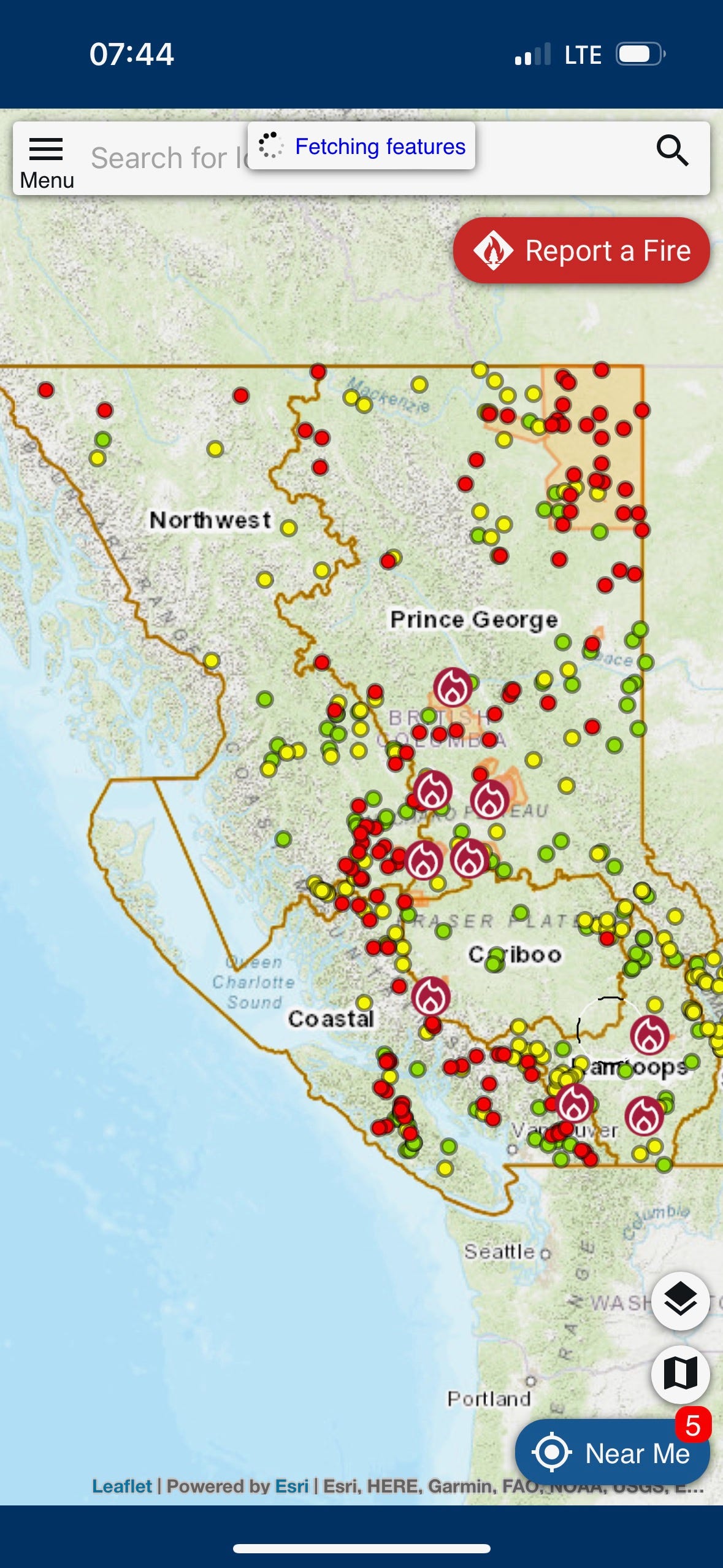
We knew gas would be plentiful from Calgary to Edmonton and Edmonton to Dawson’s Creek, in British Columba. But we were unsure of the gas situation once we left Dawson’s Creek until we arrived at Fort Nelson, our destination the following day. So, Derrick and I settled into our hotel and researched possible towns and roadside services along the quickest route to Fort Nelson. Derrick’s mapping program, however, keep diverting him to the northeast, adding a full day to our trip, when we need to travel northwest. We couldn’t figure out what was happening, then he stumbled on an app from the British Columba provincial government—BC Wildfire. Virtually the whole province of British Columba was ablaze. Derrick’s mapping program was diverting him away from the fires and the smoke-chocked roads we’d have to drive through.
Exhausted from two hard days of driving, eating nothing but fast food and snacks, I was too tired to think about alternative routes that night. We went to bed not knowing whether we could get to Fort Nelson the way we planned, or whether we would have to add a day to our journey.
Day three dawned with one decision to make: whether to press on with our original route or find an alternative way through the wildfires in British Columbia. What we weren’t going to do was add an additional day to our trip. At breakfast we watched for news reports of the fires—there were none—and checked on the latest updates in the BC Wildfire app. There was only one other possible way through the province to get us to the Alaskan Highway and into Fairbanks: a southerly course along the border of the United States, heading north before Vancouver, flanking the Fraser Plateau to Prince George, and then through the Coast and Cassiar Mountains, hooking up with the Alaskan Highway just west of Watson Lake. But that route had just as many wildfires as our original plan and added hours to our trip. We’d stick to our original plan.
We packed up and headed out of Calgary. It was a beautiful day and we made good time, only slowing once to bypass an accident. We stopped west of Edmonton to refuel and grab some snacks, and then later to grab lunch at Wendy’s. By the time we reached Dawson’s Creek the weather closed in, sprinkling then rain. The rest of the drive was gloomy and wet, which the firefighters no doubt appreciated. Not far out of Dawson’s Creek we began to see charred pines, spruce, and maples. Further on, pockets of smoke, appearing like small banks of fog (but for the campfire smell), mingled with the rain. The deeper we traveled, the deeper the burns became and the denser the smoke.
Derrick had called a hotel in Fort Nelson to make a reservation for the night. The desk clerk said the town was smoked in, situated as it was just outside an evacuation zone. With few to no other options he made the reservation. And on we drove into a darkening day, deeper and deeper into the smoke-filled wilderness. Knowing I have asthma, Derrick at one point checked the air quality at Fort Nelson. It was in the worst category. He then searched further west and found a little hamlet about three hours from Fort Nelson: Toad River. There was a lodge there and the air quality was much better. He called. They had a room available, but we’d have to arrive no later than midnight. After that, the lodge would be buttoned up. We decided to shoot for Toad River.
Visibility decreased by the hour. When nightfall came we could not see more than six feet beyond our headlights. Then, about eighty miles from Fort Nelson, visibility vanished to just a foot or two. I came upon an eighteen wheeler pulling a flatbed trailer. His rear lights made a sort of gunsight where I centered our truck, turning when he turned, slowing when he slowed. In time, other cars and trucks stacked up behind me. No one made an attempt to pass as we inched our way, never exceeding 35 or 40 miles an hour, into Fort Nelson.
We arrived just shy of 9:00 pm and made a quick stop for gas. The hotel clerk was right. Stepping out of the truck was like stepping into a smoker. Back on the road, we made our way out of town heading west—to clearer skies, we hoped. Outside town limits street lights disappeared and visibility dropped to just a few feet. While I kept my eyes on the center stripe, Derrick watched the GPS and warned me about turns ahead: “Slight right turn coming up. Turn now. Too much. Good. Now straight.” And so it went for mile after mile after mile. Five or six miles out of town we drove into a construction zone—black topped without a center stripe or shoulder stripes. Enveloped in smoke all I could see was black below and white above. I didn’t know if I was in the right lane or the left lane. I did know I hadn’t driven off into the ditch . . . yet. No way of telling how long the construction zone would last or when we would break free from the smoke I told Derrick we’d never make to Toad River, crawling as we were. Wisdom demanded we turn around and go back to Fort Nelson. And so we did.
That night in the hotel was like sleeping over a campfire. I hacked and coughed all night. In the morning I felt my back wrench with a spasm of pain. We “sleep in” to allow the sun to rise before driving that blacktop section again, but I was aching to leave Fort Nelson as soon as I thought it was safe to do so.


I don’t know how far out of Fort Nelson we were when, like emerging from a darkened room, we broke free of the smoke into fresh mountain air and an azure sky. Relief washed over us. We weaved our way through the northern Rocky Mountains of the Muskwa Range and drove through Toad River. Further on, over the pass, we stopped and gawked at the beauty of Muncho Lake—a deep, jade green glacial body held in the palm of the Terminal Range to the west and the Sentinel Range to the east. Back in the saddle, we drove north and began to spot wildlife: caribou, bison, and black bear (no mountain goat or moose). We crossed the Liard River, where we set a northwesterly course, following the river until we cross into Yukon Province and the river turned southwest. Hours later we passed Watson Lake, then a long drive along Teslin Lake, and after that Marsh Lake. Before nightfall, we reached Whitehorse, the capital of the Yukon. Finding a hotel, Derrick suggested we have a good, sit-down dinner, since we’d been subsisting on fast-food and snacks.


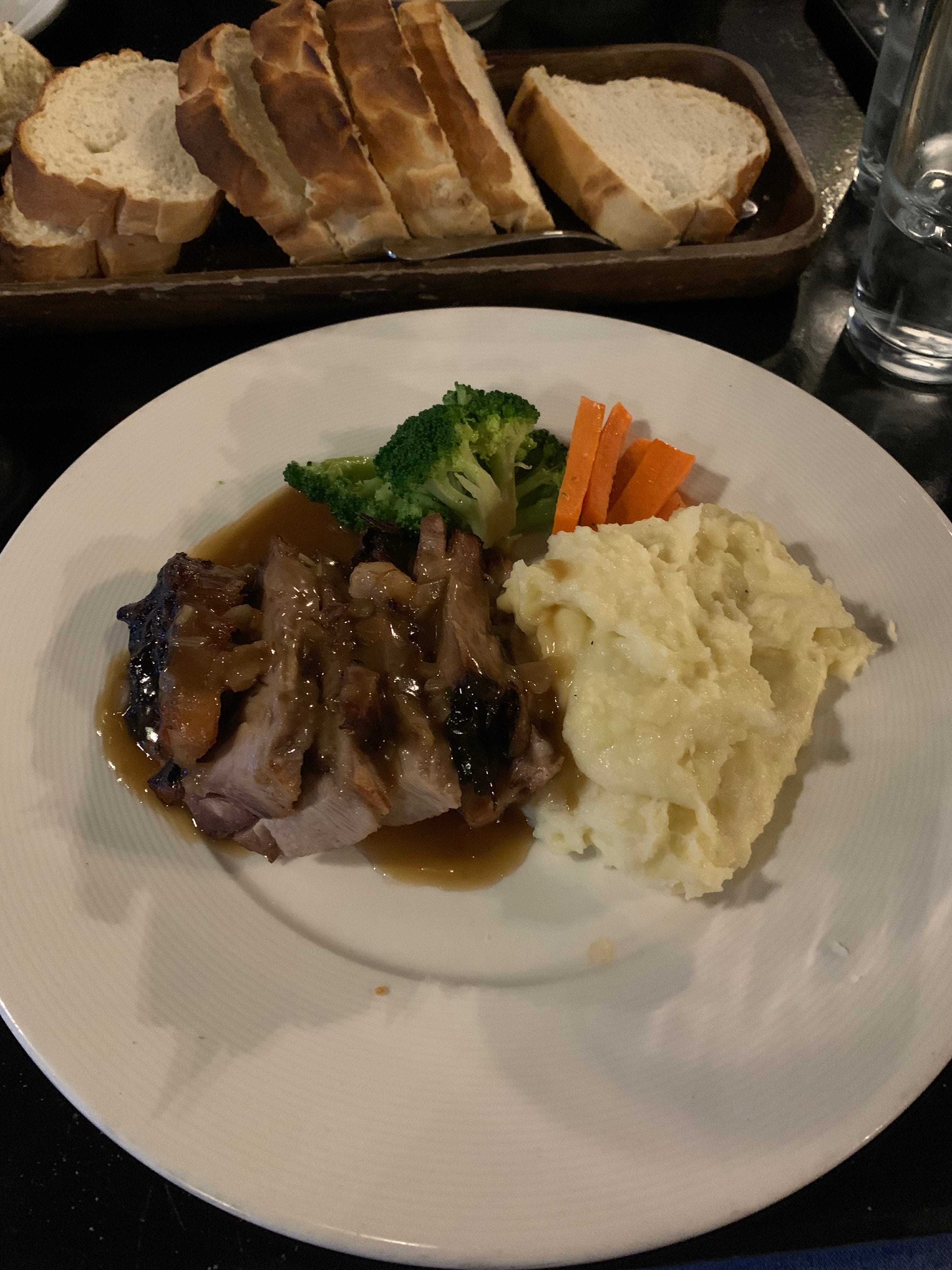
We ate at G&P on Main. A steakhouse. Steak sounded good, but the special of the day was wild boar. I’d never had wild boar before and asked the waitress if it was good. She didn’t know but a gentleman at the next table said, “It’s excellent.” Okay. I’ll have the wild boar, which tasted a bit like my grandmother’s post roast. (A decision I later regretted since it put me in the emergency room the day after we arrived in Fairbanks.) Derrick had a pasta dish with shrimp. It was nice sitting in a fine restaurant, sharing a meal, and recounting the butt pucker adventure we had the day before. We decided to turn in early to wake early and make the final push for Fairbanks.
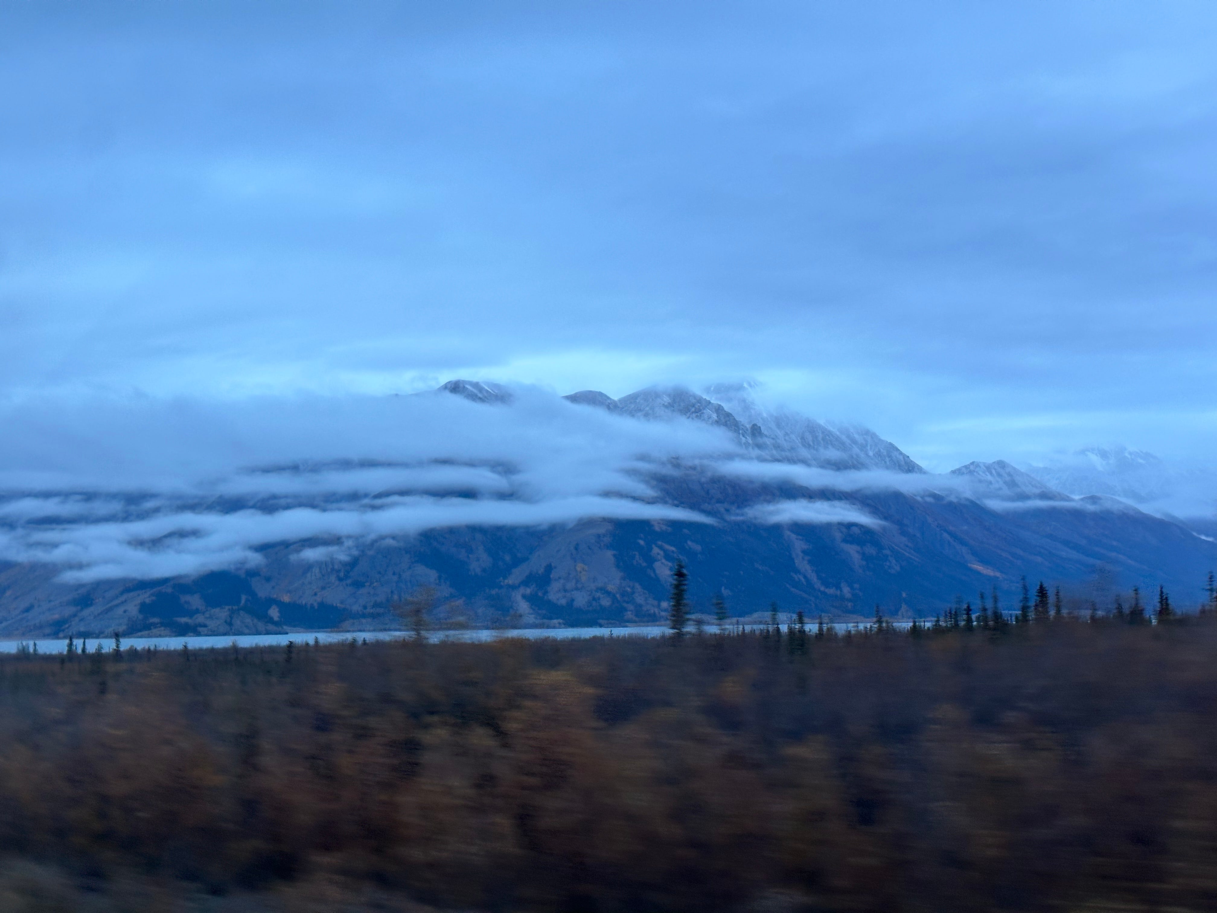
Our last day on the road was glorious. We left Whitehorse in the early hours—still dark. Heading west we drove through Indian lands. At Haines Junction we turned northwest. Nearing the Alaskan border we came upon one of the most magnificent mountain lakes I’ve ever seen: Kluane Lake. On the east are the forested hills of the Yukon and on the west is the Kluane Range. It was overcast the day we arrived. A low string of wispy clouds, strung along the range, sank just below the white-capped summits, reflecting in the blue mirrored lake. We crossed east to west over a southern marsh and the glacial fed Sims River, then paralleled the lake and the range north. When the Alaskan Highway diverted west from the lake, we stopped and drank in the beauty of the mountains. We didn’t speak, letting the wonder of God’s creative hand seep into our travel-weary souls.


A couple hours later we stopped in Beaver Creek for gas and sandwiches. Then, before we knew it, we were across the border and back in the United States, where we pulled off for a photo in front of the Welcome to Alaska sign. Through U.S. Customs at Alcan, we made our way to Tok, Delta Junction, North Pole, and finally into Fairbanks.
The journey’s end for me.
The journey’s beginning for Derrick, Virginia, and Callum.
Y’allogy is 1836% pure bred, open range Texas. As a reader-supported guide to the people, places, and past of the great Lone Star, the best way to support my work is to saddle up and ride for the brand as a paid subscriber.
If you enjoyed this article click the heart (♥︎) button. Doing so makes it easier for other folks to find Y’allogy. Thank you.
Discover more Texas related topics on my Twitter/X feed and a bit more about me on my website.
Vaya con Dios, mi amigos. Dios y Tejas, y’all.
Derrick